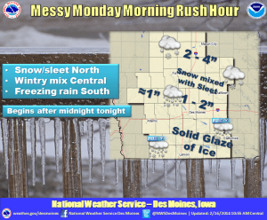
The National Weather Service reports that a quick moving upper level system will bring freezing rain to southern Iowa, wintry mix to central Iowa, and snow and sleet to northern Iowa late tonight into Monday morning. This is anticipated to affect the rush hour commute Monday morning. Generally 2 to 4 inches of snow, mixed with some sleet is anticipated over northern Iowa, generally north of Highway 30. Up to a tenth of an inch of ice accrual is expected before a band of 1 to 2 inches of snow and sleet accumulates over portions of central Iowa. The bulk of the precipitation will fall as freezing rain in southern Iowa where a tenth of an inch of ice is likely to be common by Monday morning. Generally, the precipitation will transition to all snow after sunrise Monday morning, with a few areas in the southeast continuing to see a sleet and snow mix. The system is forecast to move out of the state by the early afternoon Monday. Well above normal temperatures are expected by Tuesday and Wednesday, with 40s and 50s for high temperatures expected both days. Another system looks to bring a chance of rain and possibly a wintry mix late Wednesday into Thursday.


